sumitraenterprises111@gmail.com - View Mobile Number
- Send SMS Send Email


9.79 Lac / Piece
| Business Type | Manufacturer, Supplier |
| Power Consumption | 28 W (typical), 58 W (max) |
| Dimensions | 155 X 128 X 176 Mm |
| Weight | 905 ± 5 G |
| Click to view more | |
Product Details
IP Rating
IP54
Supported Aircraft
Matrice 400, Matrice 350 RTK, Matrice 300 RTK (requires DJI RC Plus)
Operating Temperature
-20° To 50° C
Storage Temperature
-20° To 60° C
Detection Range
450 M @ 50% Reflectivity, 250 M @ 10% Reflectivity, Max 500 M
Point Cloud Rate
Single Return: 240,000 Pts/s, Multiple Returns: 1,200,000 Pts/s
System Accuracy
Horizontal: 5 Cm @ 150 M, Vertical: 4 Cm @ 150 M
Ranging Accuracy
2 Cm @ 150 M
Maximum Returns Supported
5
Scanning Modes
Repetitive & Non-repetitive Scanning Patterns
Field Of View (FOV)
Repetitive: H 70° X V 3°, Non-repetitive: H 70° X V 75°
Minimum Detection Range
3 M
Laser Specs
Wavelength: 905 Nm, Divergence: H 0.2 Mrad / V 0.6 Mrad, Spot Size: 4 Cm X 12 Cm @100 M
RGB Camera
4/3 CMOS, 20 MP, 24 Mm Equivalent Lens, F/2.8-f/11
Video Recording
4K @30fps, FHD @30fps, Codec: H.264/H.265
Gimbal
3-axis (tilt, Roll, Pan), Angular Vibration: 0.01°, Controllable Tilt: -120° To +30°
Storage
MicroSD Up To 256 GB (UHS-I U3 Recommended), Formats: JPEG/DNG/MP4, ExFAT File System
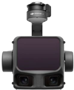
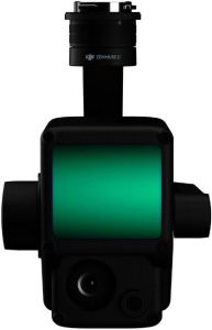
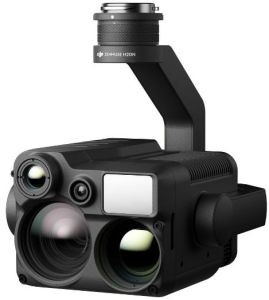
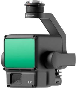
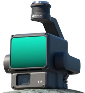
DJI Zenmuse L2 – Advanced Aerial LiDAR Solution with Enhanced Accuracy and Reliability
The DJI Zenmuse L2 is a next-generation integrated LiDAR system that combines a powerful 5-return laser module, an upgraded IMU, a high-precision GNSS system, and a professional-grade RGB camera—all built into a compact, rugged, and seamless payload. Designed to work hand-in-hand with DJI’s flagship enterprise drones such as the Matrice 350 RTK and Matrice 300 RTK, the L2 offers a substantial leap in point cloud density, mapping precision, and operational range compared to its predecessor, the Zenmuse L1. Whether you’re surveying dense forests, inspecting power lines, or modeling construction sites, the Zenmuse L2 turns complexity into clarity.
Key Features Of Zenmuse L2
1. Ultra-Dense Point Clouds with 5 Returns Per Pulse
The Zenmuse L2’s laser module can deliver up to 1.2 million points per second, with 5 returns per laser pulse, giving you incredible detail even in complex, multi-layered terrains. Whether it’s vegetation-rich landscapes, rooftops, or narrow corridors, the multiple return capability ensures that each physical surface is captured with precision, allowing for deeper analysis and cleaner 3D models.
2. Outstanding Survey-Grade Accuracy with Upgraded IMU and GNSSIntegrated with a new high-precision IMU and tightly coupled with DJI’s RTK GNSS positioning system, the Zenmuse L2 provides horizontal accuracy of 10 cm and vertical accuracy of 5 cm without the need for ground control points in many environments. The accuracy is further enhanced by improved time synchronization between the laser, camera, and positioning system, ensuring clean alignment of your point clouds and georeferenced images.
3. Professional 4/3 CMOS RGB Mapping CameraThe onboard RGB camera is built around a 4/3 CMOS sensor with a mechanical shutter and 20MP resolution, providing high-resolution imagery for colorizing point clouds and generating orthophotos. The mechanical shutter enables blur-free imaging during fast flights, and the larger sensor size ensures excellent low-light performance—ideal for overcast days or late-afternoon flights.
4. Extended Scanning Range with Greater FlexibilityWith an effective detection range of up to 450 meters at 10% reflectivity and a vertical FOV of 70°, the Zenmuse L2 expands your reach without compromising on detail. The improved signal sensitivity means fewer passes are needed to scan large areas, reducing time in the field and increasing mission efficiency.
5. Real-Time 3D Point Cloud PreviewThrough DJI Pilot 2 on the RC Plus, users can preview real-time 3D point cloud data as the drone is flying, allowing immediate verification of coverage and quality. You can visually inspect the terrain, spot missing sections, and even make adjustments mid-mission without needing to land or reprocess later.
6. All-in-One Workflow with DJI EcosystemThe Zenmuse L2 is fully integrated into the DJI ecosystem, working flawlessly with the Matrice 350 RTK, Matrice 300 RTK, RC Plus, DJI Pilot 2, and DJI Terra. From mission planning to data post-processing, the software-hardware ecosystem provides a frictionless and reliable mapping experience without third-party complications.
7. Rugged, Weather-Resistant ConstructionBuilt to operate in harsh outdoor environments, the L2 is IP54 rated, offering solid protection against water spray, dust, and airborne particles. You can conduct missions in light rain, foggy forests, or dry, dusty quarries without compromising performance or risking hardware damage.
Looking for "Zenmuse L2" ?
Piece